Introduction
In this article we ask the question “What has happened to the detail that was shown on the Draft Consultation Map issued in October 2020”. The recorded flood outlines and areas at risk on the new Development Advice Map (DAM) are lacking the detail that was shown on the draft mapping and is still basically showing the same outlines as the old defective 2017 DAM.
Rossett has been the subject of severe combined flooding from the River Alyn and the River Dee especially in 1976 and 2000 which by NRW standards equated to 1:200 (a one in 200 year) event. Rossett has had 2 such events in 45 years.
The Ministers Statement
On the 28th September 2021 Julie James the Welsh Minister for Climate Change made a statement outlining the planned reduction in development of homes in flood risk areas, she said:
“TAN 15 is clear that new developments of homes, emergency services, schools and hospitals and other highly vulnerable land uses, must not be located in areas of high flood risk without strong flood defences. If a local planning authority is minded to approve any scheme against this advice, the Welsh Ministers will be notified and able to decide the application directly”.
Our Concerns
The new Flood Mapping launched at the time of this statement does not accord with the earlier existing mapping for our area, which did not include Climate Change allowance, whereas the latest version is supposedly including climate change but the flood outlines are now lower and the mapping details do not reflect the earlier 2020 Draft Mapping.
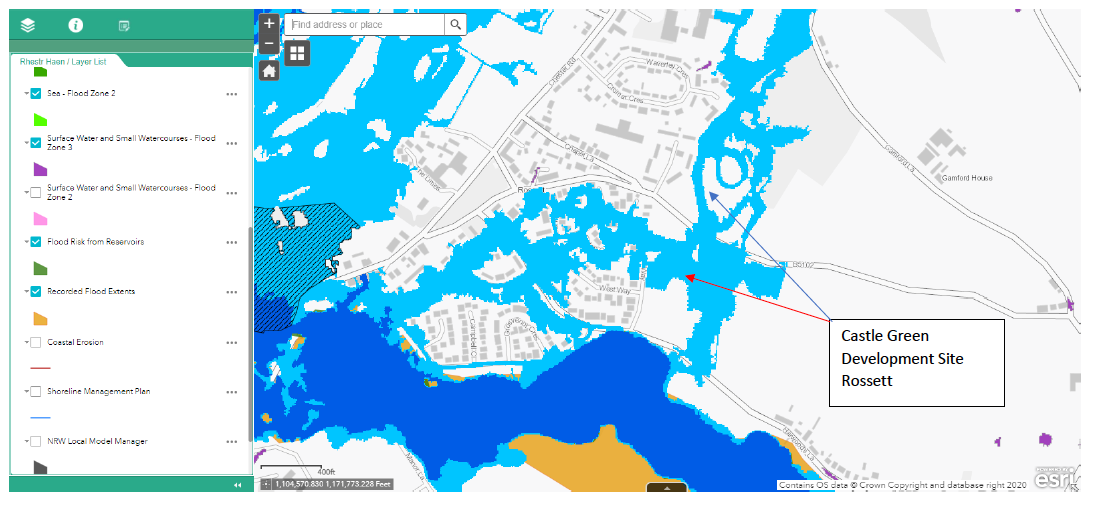
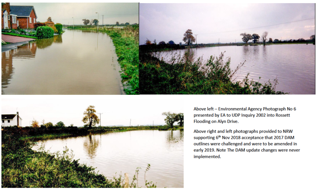
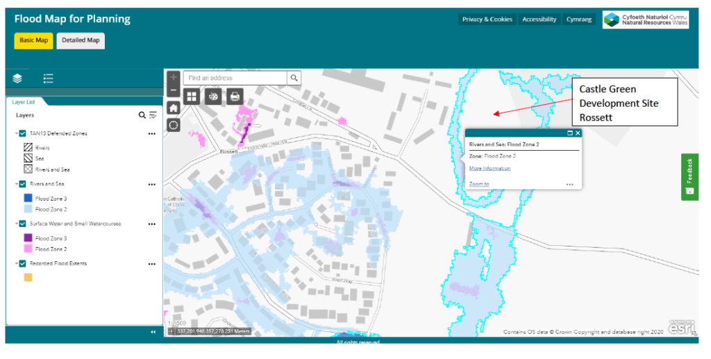
To demonstrate our concerns, we have in Figure 1, included the present DAM for Rossett, it shows the recorded flood outlines and the areas at risk in the Existing Zone B and the extent of the flooding along Alyn Drive. To illustrate the point Figure 2 shows photographs of the 2000 flood event in Rossett and the Figure 1 DAM recognises the flood levels.
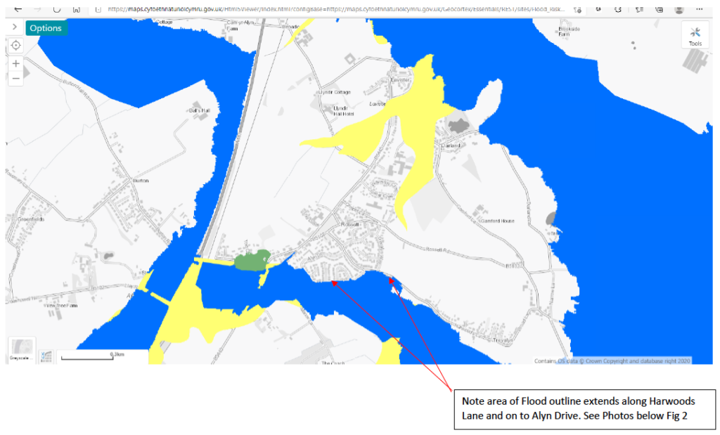
Members of the RFG contributed to the TAN 15 consultations and were satisfied with the Draft Flood Map for Planning released in October 2020, a copy of this draft map for Rossett is shown in Figure 3. The draft mapping had at that time no weight in the Planning Process but illustrated the level of information that was to be included in an updated map. The new Mapping is to be brought into use along with the new TAN 15 on the 1st December 2021.

NRW advised ( 4th Nov 2020 ) that the above development sites on Harwoods Lane are located in an undefended Zone 2 location and this is confirmed by the above Draft Map October 2020.
In November 2020 we were advised that the location in Harwoods Lane would be undefended Zone 2 and we were surprised to find the latest NRW Flood Map for Planning Figures 4 and 5 confirm that both the Southern and Northern parcels of land are located in an undefended Zone 2 location but the detail included on the Draft Map Figure 3 above is not now visible.
We are very concerned that earlier flood details are no longer displayed so we have sent a request to the Welsh Government Climate Minister Julie James to investigate this unexplained loss of detail from the Flood Mapping for Wales. We are faced with the situation that either the Draft Mapping was inaccurate or there is an unexplained omission of detail on the latest mapping.

The latest NRW Flood Map for Planning confirms that the Southern parcel of land is located in an undefended Zone 2 location (Fig 4) but the detail included on the Draft Map Figure 3 above is missing.
The latest NRW Flood Map for Planning confirms that the Northern parcel of land is located in an undefended Zone 2 location (Fig 5) but again the detail included on the Draft Map Figure 3 above is missing.
Residents will recall that we have been concerned for some while regarding the magnitude of the sudden 2000 flooding on the River Alyn from Mold through to Rossett creating considerable damage to bridges and property we can advise that the new Flood Mapping for Wales shows a flood risk layer from Reservoirs. In Rossett Case the Reservoir Flood Map shows the risk from the Hafren Dyfrdwy Reservoir at Nant-y-Ffrith high on Llandegla Moor.
We have contended that any flood risk for the Rossett Area should include flooding from both the River Alyn and the River Dee along with potential risks from Bala Lake and Nant-y-Ffrith reservoir because these were the prevailing conditions on the 6th November 2000. We still make the same contention which is now re-inforced by the Reservoir Flood Risk map layer. See Figure 6 below which is a reminder of Mold 2000 flooding extent from the unexplained flood surge on River Alyn.
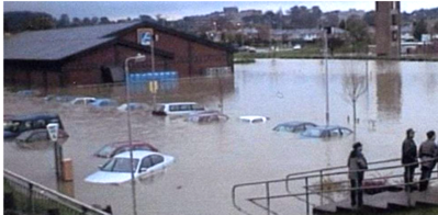
Photo Courtesy Doreen Craddock Mold Civic Society
Figure 6
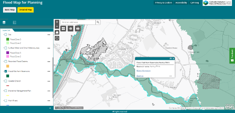
The latest reservoir flood risk map is shown below identifies the potential source of the risk as Nant-y-Ffrith Reservoir Owned by Hafren Dyfrdwy. (Figure 7). We are mindful that NRW have not been able to explain the November 2000 flood event surge flooding in Mold and all along the River Alyn to Rossett.
Summary
It appears that the details on the map layers for Rossett that were displayed on the Draft Flood Maps for Planning (Fig 3 – Oct 2020) have been lost or not satisfactorily transferred onto the new Flood Maps (Figs 4 & 5 – Oct 2021)!!
We have asked the WG Climate Change Minister to investigate the matter and we await her response, but in the meantime we draw attention to the fact in the latest round of Consultations on the Castle Green Flood Consequences Analysis and Drainage Strategy that NRW have suggested to WCBC that they should seek expert advice on the Flooding Consequences Assessment (FCA) report.
We will keep you advised on any responses or reactions to the above issues.
For information, all the figures including maps were downloaded on the 2nd October 2021 to ensure comparability.
An article on the history of the flooding in Rossett together with Photographs and a Video are available on our website, just follow the links.