This is the background story and timeline behind the whole Rossett Village Objection to Trevalyn Place and the building of 132 New Houses, accessed by a dangerous road on a Zone 2 unprotected Flood Plain, with no Access Permissions.
Introduction
Rossett is essentially an island – to the west it is bounded by the River Alyn, to the northwest is Lavister Brook, to the east is Pulford Brook and to the southeast is the River Dee. Locally the River Alyn is only 150m to the south of Harwoods Lane from the CGH Site.
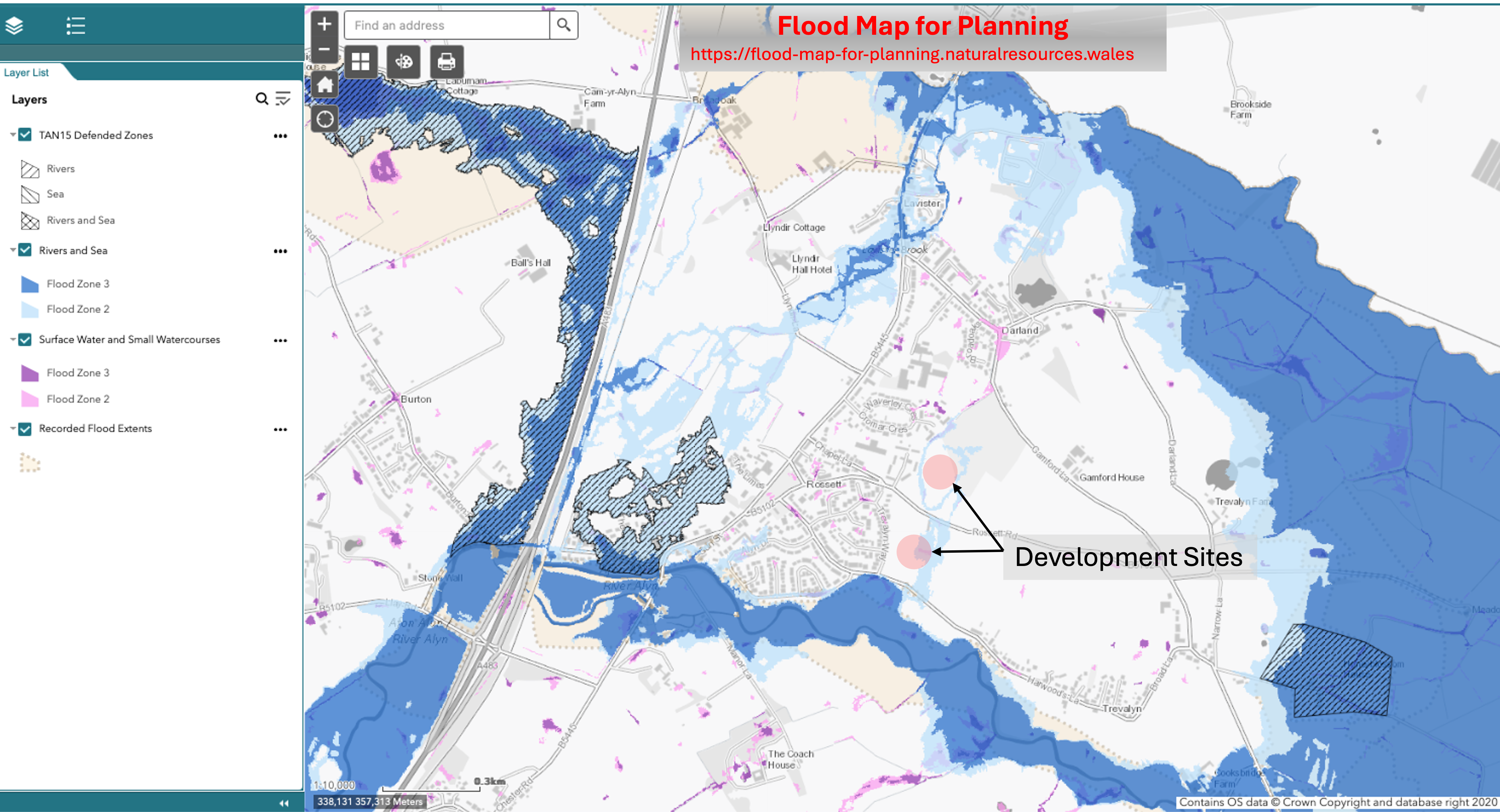
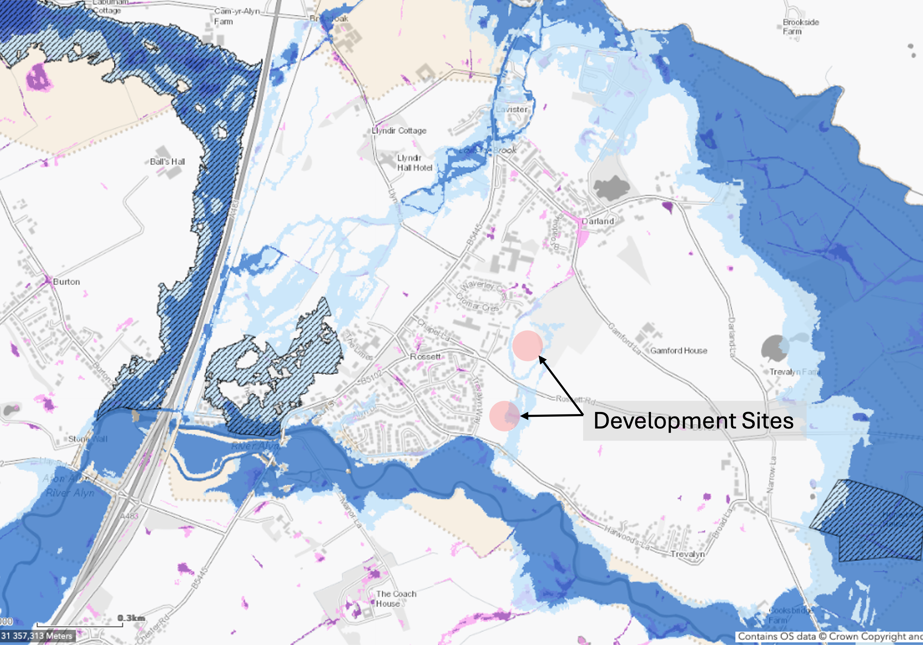
The current Welsh Government NRW flood Map for Planning clearly shows the predicted flood risk to the CGH Development Site P/2018/0560.

The above mapping demonstrates what the Rossett Villagers have been stating since 2015 that the Bellis Fields Site acquired by Castle Green Homes gives major concern to flood risks on the unprotected Zone 2 flood plain. RFG have statements from residents who witnessed the site flooding on 6th November 2000, so the flooding depicted is far from imaginary as claimed by developers’ agents. The failure to secure flood insurance in this immediate postcode area is all too real, just ask the residents.
The event chronology below is intended to assist visitors to the Trevalyn Place corner of the Rossett Focus Group website relating to Castle Green Development in Rossett. It is hoped that where there is a perceived potential conflict on what Castle Green Homes claim on their website and what RFG state we leave it to the reader to come to their own conclusions. RFG make the point that all the events shown in the chronology below are supported by documented correspondence and fully supporting information that can be viewed on request, many events are already documented in this website.
The commentary below shows quite clearly that WCBC Planning, Castle Green Homes and Betts Hydro have failed to appreciate what they have been told. In that the height of the 2000 flood, waters on Harwoods Lane were witnessed by local residents entering the southern parcel of land and was at a height of 13.86m AOD which is in excess of the raised floor levels of 125 houses.
The 132 houses are regarded as very vulnerable development and should not be allowed. If the houses are built out and occupied, they will probably be refused flood insurance. 10 insurance companies currently refuse to insure properties surrounding the site. Planning consent under which they might purchase is invalid as the site is land locked on the western boundary over which the developer cannot gain permission for access.
Rossett Flood Risk Study (NRW – 2021)
The image below is extracted from the Flood Risk Study (Page 10) with RFG annotations showing the heights of flood events over recent years. Readers must decide whether they prefer the NRW predicted flood level of 15.42mAOD that has influenced development in Rossett or whether measured top water levels in the events recorded in 1976 and 2000 are deemed more responsible and precautionary. It should be borne in mind that the above 1976 & 2000 flood events by NRW standards were deemed to be 1-in-250 & 1-in-200 year flood events but occurred before the considerations of climate change.

Chronology (in reverse date order)
2024 (1st June) With the failure of this development to gain proper and unrestricted access to the land, purchasers of the houses may find that they cannot secure mortgages on properties.
2024 (May) WCBC issue instructions that the land they annexed in Trevalyn Hall View should be re-instated.
2024 (17th February) Application to revoke Planning Consent P/2018/0560 and all matters pursuant thereto submitted to WCBC Planning.
2024 (31st January) Letter to WCBC Legal Officer repeating the request of 11th September 2023 to declare all approvals since 7th February 2022 Planning Committee invalid.
2024 (28th January) Final Objection reminder to Planning that development is an undefended Zone 2 flood plain and the access locations have not been set out in accordance with the OPP and the CGH Development scheme should be refused
2024 (January) WCBC Planning Officers gradually Discharge Planning conditions on the basis that the site will not flood from the Chester Road Alyn Bridge, they have ignored the facts that the site has always flooded in living memory from the farm fields and track in Harwoods Lane south of CGH Trevalyn Place.
2023 (11th September) Letter to WCBC Legal Officer to declare Reserved Matters invalid on the grounds that the access points cannot be varied from those of OPP
2023 (20th August) Objection to Application for Signs & Flagpoles as the application casts further doubt on the validity of the Reserved Matters Approval on 11th February 2022 and requires investigation.
2023 (17th April) Formal objection to Drainage Strategy as potential ground water contamination by a flooded sewage pumping station not satisfactorily addressed.
2023 (15th January) RFG formal objection to the discharge of Arboricultural Plan and Lighting Plan as they do not accord with access locations set at OPP and should be refused.
2023 (15th January) RFG formal objection to the discharge of Conditions 8 and 9 relating to Highways and Footway proposals for the above CGH Development. The approval contains Grampian Conditions 8.3 & 9.3 which require a safe pedestrian access along the Holt Road which cannot be achieved.
2022 (21st November) NRW admit that they have no evidential basis to claim that their top water outlines in the area extracted from a Police Helicopter Flyby video are correct. Formal attention drawn to the failure to advise the Planning Committee on the important 2021 WG Minister September Statement and the December 2021 Chief Planning Officer guidance on Tan 15(2021).
2022 (20th November) Another formal objection to the Holt Road Footway scheme. The proposals fail to meet the requirements of Active Travel Wales, the requirements of the Manual for Streets and Inclusive Mobility.
2022 (22nd July) NRW finally agree that their Flood Risk Modelling could not reach the recorded flood heights at the Chester Road River Alyn Bridge and that the CGH Site at Trevalyn Place is a Zone 2 unprotected site and will flood like others around Wales with OPP. Latest Flood Maps for Planning show Trevalyn Place flood risks.
2022 (8th May) Another formal objection to the Holt Road Footway scheme being proposed by Castle Green Homes. Footway plans radically wrong and unsafe.
2022 (8th May) RFG challenge SUDs scheme which shows risk to ground water from potential contamination by flooding to sewage pumping station at the low point on the development when all surface water run-off from over 120 properties directed to infiltration basin adjacent to sewage pumping station.
2022 (11th April) RFG Objection to WCBC Planning as foul drainage plans do not accord with Building Regulations Part H4.1.5 as only 1 property appears to comply with not over building long foul drains without the owner permission, 406 breaches detected on plans to 131 properties.
2022 (23rd March) NRW finally admit that they have no evidence of 2000 flood event as Police Video taken on day after peak flood on 6th Nov 2000 had been destroyed.
2022 (7th February) Trevalyn Place (P/2021/0110) goes to WCBC Planning Committee and Planning Case Officer conceals from Committee WG guidance not to raise ground levels on greenfield sites and the changes to the flood plain designations from A & B to Zone 2 undefended
2021 (1st November) RFG formal Objection to discharge of Holt Road Footway as all pedestrians must step into a live carriageway for over 26.0m at the narrow pinch point on Holt Road at the Green.
2021 (28th October) RFG further objection to Planning re CGH flood risk modelling and discharge of SAB approvals as 2000 flood levels not taken into consideration.
2021 (5th October) RFG formal objection to dangerous footway proposals on Holt Road and reminder that pedestrian access links on the western boundaries cannot be provided on both the North & South Parcels of land and cannot therefore comply with WG Minister Conditions set at OPP.
2021 (28th September) Another formal objection to raising site levels in contravention of Policy EC12 and confirmation that NRW advice is that the flood plain designation on which the development is proposed has changed to Zone 2 unprotected.
2021 (12th September) Formal Objection to lack of car parking on Trevalyn Place Development still 25% short of standard referred to in Appeal Application.
2021 (8th September) RFG formal objection to Planning re CGH Flood Consequences Assessment and Drainage Strategy.
2021 (8th August) RFG formally object to Planning about the dangerous footway proposals being encouraged by WCBC Highways Officer, in addition to the reminder about lack of access to meet imposed OPP conditions.
2021 (1st August) RFG formally object to raising of site levels to development to overcome flood risk. Proposals are contrary to WCBC Flood Policy EC12 & EC13.
2021 (20th July) RFG object to the inadequacy of parking proposals on CGH Site as they do not meet the standard indicated at appeal or meet WCBC SPG 16e – shortfall of 25% parking spaces.
2021 (20th July) RFG Objections to Planning on CGH (Betts Hydro) Flood Consequence Assessment (FCA) plus letter to Betts Hydro regarding recorded flood levels on Harwoods Lane, there was no reply!
2021 (11th July) Formal objection by RFG to Planning on CGH Development outlining failures of development scheme to comply with OPP and accesses to site.
2021 (21st May) Formal RFG Objection to Planning re CGH Development depicting recorded flood heights and especially flooding risks and associated NRW challenge correspondence.
2021 (13th May) Rossett Community Council write to advise that pedestrian site access into Trevalyn Way was not possible as CGH have no control over 3rd Party Land fronting Trevalyn Way not in CGH ownership.
2021 (30th April) Rossett Focus Group letter to CGH pointing out that their proposed development layout did not accord with the Outline Planning Permission – sent by email and tracked postal delivery. No reply.
2021 (27th March) RFG formal objection to CGH layout not showing access points in accordance with OPP as a result Conditions cannot be discharged to allow development to proceed.
2021 (17th March) RFG formal objections to Planning re layout, scale and appearance together with detailed flood evidence of why the development should not be approved or furthered.
2021 (25th February) CGH submit scheme to WCBC Planning Department that does not comply with the OPP granted by the WG Minister.
2020 (7th September) NRW Admit that they have no details of 1964 and 1976 flood events. As far as the 2000 event data on flood extent taken from Police Helicopter video NRW still insist on top water levels obtained therefrom..
2020 (March 17th) A Caveat Emptor Letter sent to CGH explaining on the historic flood risks and advising against purchase of the development site all of which was ignored.
2020 (February 14th) WG Minister Julie James grants Appeal (OPP) with Conditions. Interestingly the access plan refused by the WCBC Planning Committee was different from that which emerged from the Appeal.
2019 (June) Bellis Agent submits an Appeal on P/2018/0560 and a fresh Application P/2019/0460 to develop 132 houses on the same site.
2019 (7th January) Planning Committee consider the Officer Report in which the Planning Case Officer decries the ability to obtain flood insurance contrary to 2014 WG Guidance on Flooding and Insurance and refuted local site flooding claims.
2018 (Nov) Rossett Village successfully challenge the NRW River Alyn Flood Mapping adjacent to Bellis Fields (Now CGH Site Trevalyn Place). In spite of agreeing that the map outline adjacent to the CGH Site on Harwoods Lane NRW fail to implement the map changes until 2022
2018 Consultation on 132 Houses on Bellis Fields takes place with a formal objection from Rossett Village on the flooding risks as WCBC Flood Records did not start until 2010.
2015 Proposals put forward by an agent for Bellis Bros to build 137 houses on land north & south of Lane Farm Rossett Road Trevalyn LL120DS.
2004 The Welsh Government publish TAN15 – Technical Advice Note 15 Development and Flood Risk (2004). This TAN established that Planning needed to take into account Flood Consequences Assessments (FCA) using 1:100 event flood data.
2002 A planning inquiry was established to examine the plans for 15 houses in Alyn Drive Rossett opposite Brandon Grove. The Planning Inspector decided against the Alyn Drive site due to flooding risks. In addition, the CGH northern parcel of land was included as a potential development site but this was rejected on the grounds of Flood Risk.
2000 Major flooding again occurs with the River Alyn reaching a height of 15.79m AOD in Gun Street and Alyn Drive. Sandbags were issued to dozens of residents in the area.
1976 Major flooding occurs to Rossett Village with the recorded flood height close to the Chester Road Alyn Bridge in Gun Street reaching 15.89m above ordnance survey datum, (AOD). Harwoods lane and surrounding fields were flooded from the farm track south of Harwoods Lane. Trevalyn Hamlet was cut off for a week before Harwoods Lane was passable.
1950s Wrexham Council build 35 houses on Trevalyn Hall View Estate, then abandon further development due to the high-water table and curtailed the extension of Trevalyn Hall View into the northern parcel of land now owned by Castle Green Homes.
18/19th Century – detailed research into archives has revealed that Rossett has a history of flooding virtually every 20 to 25 years and the flood records have been traced back to the 1790s. This is the reason that most development over the centuries has been on the highest ground in the village.
Trevalyn Place – Final Thoughts
There is potential flood risk to 125 houses that have finished floor levels lower than the recorded flood heights on Harwoods Lane of 13.86m AOD in Nov 2000.
Flood insurance may not be available.
CGH have no agreements in place to cross 3rd party land, hence planning consent proof for onward sale may be jeopardised.
The Holt Road does not meet the mandatory standards of footway for the planned alterations and requires users to walk in a live carriageway as the footway cannot be improved properly adjacent to Green Farm Mews and the Green.
The above chronology and story has been edited to reduce the reader’s valuable time. A more detailed story is available if required, but most issues have already been covered throughout this website.


