NRW Confirm Site Flood Risks to 132 New Houses in Rossett
After 4 years of battling flood risks with National Resources Wales (NRW) it has been confirmed that the residents of Rossett were totally correct in their opposition to any major developments in Rossett. The floods experienced in years gone by were very real and not imaginary as claimed by Developers and supported by NRW, and these will actually happen again.
At a meeting chaired by Wrexham MP Sarah Atherton between National Resources Wales (NRW) and members of Rossett Focus Group (RFG) it was finally agreed by NRW that sites throughout Wales like the above were actually at risk of flooding in spite of their flood modelling.

God Help Them – Daily Post Article
The Wrexham areas of Burton, Rossett and Almere are historically associated with major flooding once every 25 years – and the last one was 24 years ago. Not surprising then that plans for a new housing estate in Rossett have raised more than a few eyebrows.
RFG successfully challenge NRW
RFG successfully challenged NRW on the evidence held that enabled them to claim that there was no risk of flooding. Several freedom of information requests (FOI) to NRW for copies of their evidence showed that the existing Rossett Residents and those in the proposed 132 houses on Bellis Fields would not flood revealed that NRW have no such records.
NRW actually had accused RFG Members in the recent past as being vexatious in their information requests. The final request (FOI) before Local MP Sarah Atherton arranged the above meeting was for a copy of the Police Helicopter Fly by video on which NRW had based all their advice and drawn their top water map flood outlines. The RFG request was based on the belated discovery of evidence submitted by a Flooding Expert to the 2002 UDP Flood Inquiry which showed that the video was taken some time on the 7th Nov 2000 the day after the floods had abated.
The NRW response to this FOI request was “we no longer hold a copy of this footage, as it is past our retention schedule”
In addition to the above information requests, NRW Flood modelling for Rossett (RFRS) was challenged as being unrealistic in comparison to the observed flood events in 1976 and 2000. The recent meeting confirmed that NRW modelling could not reach the heights of observed flooding events. RFG have now provided topographic details and associated photographs to enable NRW to undertake revised and perhaps now some credible flood risk modelling.
Crucial Evidence by Former Rossett WCBC Duty Flood Officer
Crucial evidence in the meeting was given by the Former Rossett Duty Flood Officer for WCBC. He was able to confirm what flooding occurred on the 6th Nov 2000 in Rossett and where his team had placed sandbags to protect properties in the Alyn Drive area, Trevalyn Way and high on Harwoods Lane to prevent flooding to the whole of Trevalyn Hamlet.
The agreed summary of the RFG/NRW meeting notes are as follows:-
“NRW admitted that their monitoring of the Alyn Bridge was defective and did not know how to put things right but the maximum height of the River since monitoring commenced is 2.337m above normal and this effectively related to a 1 in 100year event (1%event) on the 20th Jan 2021.
NRW position is that they only are required to model a 1 in 100 year event with a blockage at Alyn Road Bridge and that the developers FCA with an increased sensitivity 2m grid satisfied this requirement. It was confirmed that where the LPA had details of flood events greater than the modelling required by TAN 15 2004 this should have been brought to the attention of the WCBC Decision Makers. In addition NRW did not insist on the mitigation measures of raising site levels and excavating flood basins contrary to their written conditional acceptance of the measures.
Questions re flood basin would have to be directed to Wrexham Council. RFG made it quite clear that in spite of NRW assurances they did not accept that the RFRS had properly taken into account the River Dee impact on the flood levels observed in both 1976 and 2000. Finally NRW advised that due to the suspension of TAN15 2021 there would now be planning approvals, like this one, around Wales in areas that are known to be at flood risk under TAN15 2021”.
Greater Flood Risk!
The greater flood risk is in main due to the suspension of TAN 15 (2021) in November 2021 by the current Welsh Government Minister for Climate Change Julie James. This new updated TAN 15 was announced by Julie James in September 2021 to a great fanfare claiming it took into account climate change. Ironically it was the Wrexham MS Minister Lesley Griffiths who declared a Climate Emergency for Wales back in April 2019 – it is 3.5 years since the announcement, we don’t appear to have much progress given it was an EMERGENCY!
In a BBC article (March 2020) the CEO of Flood Re stated “Government guidance is very clear that new properties should not be built where they will be at risk from flooding.”
Next Steps for Rossett Focus Group
The next step for RFG is to make further objections to Wrexham Council SAB (SuDs Approval Board) regarding the latest NRW revelations, in order to ensure any CGH (Castle Green Homes) scheme flood mitigation is properly evaluated in the light of the earlier above confirmed flood risks.
In the event that the SAB representations are unsuccessful deeper flooding like those mentioned above or even 1:100 floods shown above are expected, with run off into Trevalyn Way, Trevalyn Hall View and Darland View. If against all historic flooding evidence CGH Development proceeds unhindered by SAB then the flooding run off from the existing fields into surrounding resident’s properties will increase substantially posing additional risks to areas down the catchment in Darland and Lavister.
Flooding History
It should be noted that NRW Records of River Levels in Rossett did not commence until 2010, this was after the raised height flood defences on Station Road Rossett were constructed. The maximum height shown on the NRW Flood Graphic of 2.193m is in error (see meeting notes). The maximum height on the River Gauge is confirmed at 2.337m above normal and occurred on the 20th Jan 2021 (Storm Christoph related). No gauging records exist prior to 2010 in Rossett, earlier records exist only at Pont-y-Capel Gauging station which is some 3.5km upstream of Rossett.
NRW confirm that they have all the photographic evidence relating to the 2000 event that the Environment Agency Wales presented to the Wrexham UDP Rossett Flood Inquiry in 2002 but the records are not held in one place. NRW also confirmed in discussion that they are not able to achieve flood modelling results that reached the heights of the observed flood events in 1976 or 2000.
During our investigations into flooding evidence we have been able to establish along the way why Insurers will not cover many locations in Rossett. Although using the same base mapping, Insurers take the flood modelling predictions very seriously and base their decisions on the top water levels predicted but NRW only use for guidance their 1:100 consideration under TAN15(2004) which apparently results is considerably lower flood risk predictions.
Issues such as these will be taken further by RFG.
As of today…….. The RFG have submitted a detailed objection to the Wrexham County Borough Council SAB regarding flooding and drainage issues. We also await the outcome of our Appeal to take forward our Judicial Review request.
Wrexham Council
In January 2016 Wrexham CBC issued a Pre-Consultation Draft “Flood Risk Management Plan“.
If anyone can find the issued plan please let us know!
On suspension of TAN 15 in Nov 2021 Julie James said that she “required every local planning authority to complete work to review, within the next 12 months, the strategic flood consequences assessments (SFCAs) for their area, either individually or on a regional basis. I also require each local authority, working in partnership with other flood risk management authorities where appropriate to identify a pipeline of priority flood risk management schemes to address flood risk and vulnerability.” —Anyone seen Wrexhams SFCA?
The Welsh Government document “Sustainable Drainage (SuDs) Statutory Guidance” on Page 3 states: “It is important to note that construction work which has drainage implications must not be commenced unless the drainage system for the work has been approved by the SAB.”
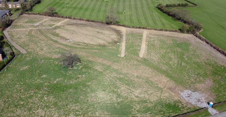
Left: Drainage works on North Field
The Wrexham Planning Enforcement Officers seem to be unaware of this requirement as they allowed Castle Green Homes to commence drainage work on the North Bellis Field, this despite no SAB Approvals, representations from both the Rossett Focus Group and our Local Councillor who was fobbed off with an excuse by Officers that the works complied with Agricultural Improvements! It was also noted that the Ecology Officer paid no attention to the destruction of wildlife habitats during all the works.
Links to More Detail………….
Flooding on 6th November 2000 -The flooding is known to have peaked at a height of 15.79m Above Ordnance Datum (AOD) at 11:45pm on 6th Nov 2000.
A 19 Minute Video of the above flood.
History of Previous Flooding – 1950 to 2020 – Rossett is a village with a recent history of flooding. A number of planning applications by housing developers have been rejected over the years, some were appealed but still not granted.
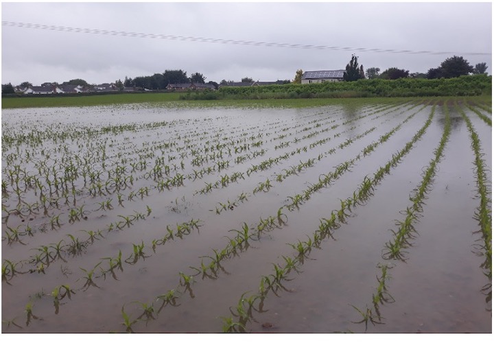
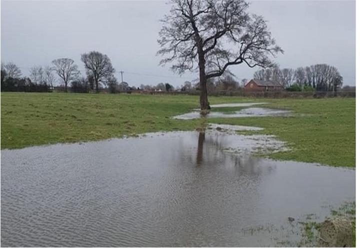
Gallery of Flooding Photographs – Images of the floods from 1976 to the current day.
Sarah Atherton MP
Member of Parliament for Wrexham
In flooding news, since August 2020, I have supported the Rossett Focus Group (RFG). The RFG was formed by a small number of local residents in response to an unwanted proposed housing development on land that was, and still is, prone to flooding. Their objection is based on the flood risk of the land proposed for development in Rossett by Castle Green Development. As the situation evolves, I chaired a meeting between Natural Resources Wales and RFG to ensure both sides could put forward their case. I will continue to support Wrexham residents in any way and ensure that constituents’ voices are heard within the local planning processes.
—Essentials Magazine Aug 2022—