Introduction
This objection to the proposed Flood Consequence Assessment (FCA) builds upon the previous objections submitted regarding the Site Drainage Proposals. The latest FCA does not overcome the flaws previously reported neither does it address the Objections lodged by NRW on the 28th May 2021 nor does it address the NRW concerns expressed on the 27th July 2021 now that the proposed earth bunds have been removed from the plan.
The following will comment on the relevant paragraphs and sections of Betts Hydro Final FCA dated August 2021. It is apparent from the comment in paragraph 5.1.11 that the drainage proposals are still in their infancy and that much more work is needed before a satisfactory SUDs scheme can be developed by Betts Hydro. This objection addresses the inherent flaws in the Betts Hydro Hydraulic Modelling and the assumptions still being made to justify uplifting both parcels of land from Harwoods Lane through to Darland View.
There seems to be the belief in Betts FCA that the applications being made by Castle Green Homes are for an outline planning consent rather than Reserved Matters or Discharge of Conditions. See Paragraph 1.2.1.
Summary of the Many Issues
Unbelievably this is the 6th FCA to be submitted and the content is no better than the previous 5 as it still perpetuates building up the site levels in contravention of WCBC Planning Policies on flood risk and Tan15.
The time has come for the Developer to be instructed to withdraw from this matter as the sites under consideration cannot be developed due to inherent and unsurmountable flood risk matters. Submission of further FCAs on the principle of raising ground levels to unacceptable heights and to place surrounding properties at further flood risk is just not good enough and will continue to raise further objections.
The Developers Agent in 2019 claimed that the development site was totally free of flood risk, this does not appear to be borne out by this latest 6th FCA attempt to persuade those in surrounding properties that this is true. Based on their own flood exposure experiences over at least the last 25 years they know that flooding of the site has been a risk for many years and will continue so to be with the climate change now upon us.
The FCA and the Preliminary Drainage Strategy are seen as an elaborate plan to obfuscate the real flooding risks to the development and to the surrounding areas just to facilitate building of 132 houses in spite of the topography and the location adjacent to a C2 floodplain.
The hydraulic modelling results have been processed in such a way that they bear no relation to NRW (EA) photographic records on the flood levels experienced on the adjacent flood plain, neither do they accord with any influence of the River Dee. They also fail to recognise the sources of historic flooding that has occurred to the Northern Parcel of land and propose mitigation measures such as wholesale site uplifting that will increase flood risks both on and off site.
Overall, the FCA and Preliminary Drainage Strategy cannot be accepted as being properly researched and plausible as it will contravene TAN15 provisions and the WCBC Policies EC12 & EC13. As a result of the cumulative failures to provide a safe and demonstrable Surface Drainage Scheme that will not harm the safety and well-being of others the precautionary route as advocated by TAN15 should be invoked and development refused.
The advice given by NRW regarding the increased risks to flooding off site have not been heeded and as a result Condition 7 cannot be discharged.
Site Context
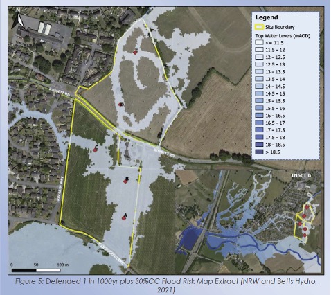
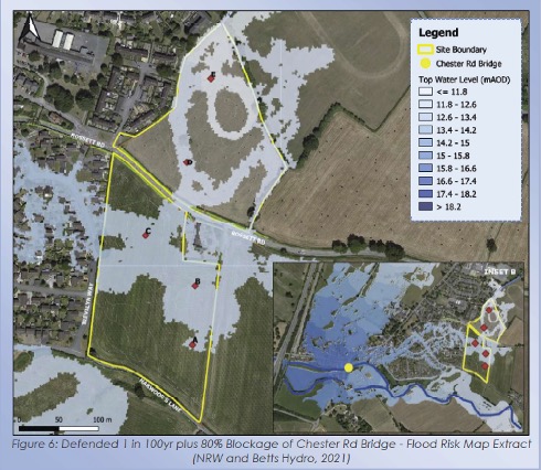
Betts FCA includes the following: Figure 5 is attributed to NRW Mapping showing site flooding from the Harwoods Lane area the second Figure 6 showing Betts site flood predictions from a blockage at Chester Road (B5445). It is contended that the hydraulic modelling produced by Betts is still not representative of the flooding experienced in Rossett since 1976 and it fails to recognise anywhere the Environmental Agency Wales (EA) flood photographs entered into evidence to the UDP Inquiry in 2002.
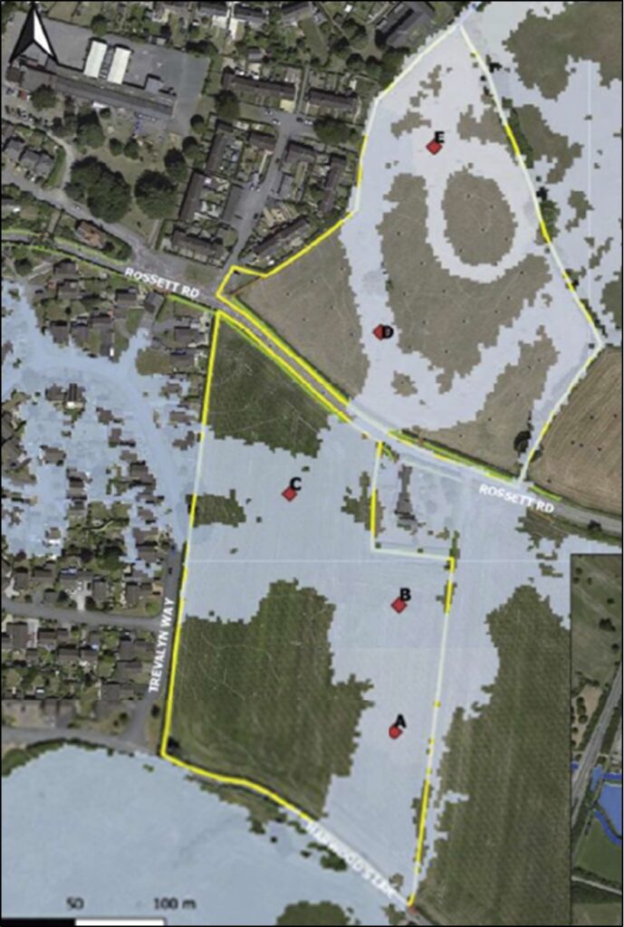
The Figure 2 below is a result of the combination of the 2 maps submitted by Betts in their FCA and demonstrates that both North & South parcels of land planned for development are predicted to be substantially flooded both in normal flood events and the blocking of the Chester Road Bridge.
Building Justification
The FCA is required to justify building in an area covered by TAN15, Betts Hydro FCA continues to fail to justify building in such an area and their subsequent Drainage Management Proposal will lead to both serious flooding on and off site. Betts Hydro Paragraph 1.2.2 still claims that “No flooding will occur to the development site or surrounding area due to the proposals including surface water and sewers.”
Examination of Betts Hydro FCA still shows that very little historic investigation has been carried out into the flooding in the area in spite of being provided with details of Flood Photographs held on this RFG Website or being provided with copies of EA the Environmental Agency Wales (forerunner of NRW) showing flooding to the fields and roads immediately abutting the southern parcel of land. The hydraulic modelling undertaken is deficient in that it fails to accord with measured flood levels in EA photographs and predicts peak water levels much less that those experienced in the flood events of 1976 and 2000.
The investigation work undertaken by Betts is so poor that it has not identified the September 1976 flood event that even NRW with their scant records acknowledge took place. A simple online internet search for “Rossett Flooding” reveals the RFG Website and there for everyone to see is a set of flooding photographs centred on Rossett. Folders showing 1976, 2000, 2019, 2020 and 2021 are readily visible together with written articles on the flooding to the village of Rossett. A 20-minute video of the November 2000 flooding to the whole area is also posted on the website.
Betts Hydro FCA makes reference to the NRW Rossett Road Flood Risk Study (RRFRS) carried out in 2020. This study has already been commented upon and concentrates mainly on the defended area of Station Road. The study in its top water level (TWL) fails to inform properly on the situation recorded in Nov 2000. The study concludes that the (RRFRS) TWL of 15.42m AOD predicted is a good correlation to the flood levels experienced in Nov 2000 for a predicted 1in 200 year event.
The latest NRW predictions including climate change do not reach the levels experienced mid afternoon on the 6th Nov 2000 15.51m AOD nor do they approach the final late night TWLs measured at Alyn Drive 15.79m AOD. Two 1 in 200 events have been experienced in Rossett in the last 44 years and these have occurred in 1976 and 2000 respectively and there are no defended locations below the Alyn Road Bridge. The 2000 event levels were actually exceeded in 1976 when the River Alyn reached a height of 15.89m AOD in Gun Street adjacent to the Chester Road Bridge.
The RRFRS cannot be judged to totally inform this FCA as the TWL in Alyn Drive as depicted by EA photograph No 6 is higher (14.53m AOD) than the 2020 NRW Study modelling suggests. It can be seen from the 2020 NRW Development Advice Maps that the TWL of 15.89m AOD has been used to depict and inform the flooding risks in that area. It is therefore unacceptable that the NRW RRFRS 15.42mAOD is used as a starting level for any FCA when the TWLs in Gun Street are 0.47m higher than that mentioned and there is no defended location below the Alyn Road Bridge.
Site Walk Over and Plans
Betts Hydro FCA Appendix G contains the same misleading information that it contained when the 1st draft appeared back in April 2021. The photographs were not taken close in time to the height of the flood incident on the 20thJanuary 2021 but some 2 days after the event, when the peak had long gone. Their usefulness only goes to confirm what has been stated by local residents that in extreme weather conditions large parts of both the northern & southern parcels of land do not drain and that in the absence of additional rainfall the flooding will eventually evaporate or can only slowly infiltrate the ground.
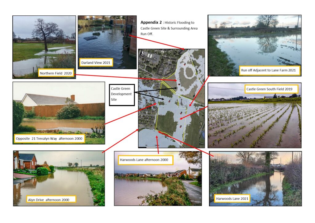
What the walkover photographs demonstrate is that there is substantial flooding in the area of Lane Farm and the adjacent fields. The Betts proposals will make this situation worse. Fig 3 below illustrates the various flooding situations that have occurred on or adjacent to the site since 2000.
Hydraulic Modelling
Betts Hydro still continue to make great claim to the direction of flooding to Trevalyn Way and the southern parcel of land. It is not surprising that Betts have even got this wrong as there is a complete failure to comprehend the influence of the River Dee on the flood risks associated with the River Alyn. Any longstanding resident of Rossett can advise that when the River Alyn overtops its banks in the vicinity of the development sites the direction of flow is always from the River Alyn up the farm track to the south of Harwoods Lane.
The theoretical direction of flow with a major blockage of the Alyn Road Bridge B5445 may well indicate a flow through the village towards Trevalyn Way but history has shown on all occasions that historic flooding to Harwoods Lane and Alyn Drive has all stemmed from the farm track and field’s south of the developments site confounding this hypothesis. This direction of flooding is confirmed by Betts Hydro including in their FCA NRW Figure 5 (shown above). The latest FCA Para 5.1.11 indicates that Hydraulic modelling is still to be carried out, perhaps this time more accurately than the last attempt bearing in mind all the extra local information that has been made available.
The 2000 event flooding runoff depicted in Trevalyn Way emanated from the southern parcel of land now planned for development. We have previously provided testimony from Mr D G the former NRW (EA) River Alyn team leader regarding the positive impact that the height of the River Dee and its effect on the River Alyn. This early advice from Mr D G has gone unheeded although a copy was provided to Betts Hydro. Current residents have personally witnessed the 1976 flooding, which is not acknowledged by Betts, these residents recorded the flood outlines both in Gun Street Rossett and Harwoods Lane and these are now more or less correctly shown on the current Development Advice Maps
A complete commentary on the Hydraulic Modelling was submitted to WCBC Planning Comments on the 21st May 2021 outlining the omissions and shortfalls in the analysis and that flood outlines chosen did not reflect the NRW (EA) Evidence used in the UDP Inquiry nor did the outputs recognise the importance of the River Dee on any Hydraulic Modelling on the River Alyn. Comment has already been made regarding confidence levels on the base data provided by NRW to Betts Hydro and the NRW Rossett Flood Risk Study Report peaks do not accord with the photographic evidence contained within the Rossett Flood Risk Study Report.
The base NRW modelling with climate change does not equate to the 6th Nov 2000 flood levels measured at the boundary of 37 Alyn Drive Rossett and the NRW prediction of peak predicted flood water level of 13.60m AOD certainly does not accord with the accredited NRW(EA) Photographs showing year 2000 flood runoff water into Alyn Drive at 14.53mAOD. None of the modelling outputs provided by Betts Hydro show any peak predicted levels in excess of 14.00m AOD in the fields immediately south of the development site abutting Harwoods Lane and these modelling outputs are supposedly inclusive of climate change.
It cannot therefore be accepted that the Hydraulic modelling, as it stands, provides any useful information purpose to evaluate the flood risk posed to and by the development because it is lacking in too many areas and makes too many assumptions without clear evidence to be meaningful.
It would appear that Betts Hydro are relying on Tan15 Figure 1 Table Item B which states “if site levels are greater than the flood levels used to define adjacent extreme flood outline there is no need to consider flood risk further”. The lack of analysis work undertaken by Betts does not confirm this to be the case, NRW (EA) evidence photographs show the opposite to be true and that the adjacent southern field recorded photographic flood levels are in excess of the topographic levels of the field abutting Harwoods Lane so the precautionary approach to this development should be invoked.
Raising of topographic levels to impede flood waters either pluvial or fluvial will increase flood risks in the surrounding areas contrary to TAN15 Section 8 and WCBC Policies EC12 & EC13.
Reservoir Flood Risk
The Betts FCA contains a dismissive reference to the risks of reservoir flooding to Rossett or this development. NRW have denied that they have any reservoir assets or any sluice gates higher up the River Alyn but NRW have been unable to explain the phenomena which occurred on the 6th November 2000 which resulted in central Mold being flooded to a depth of 1.20m and flood damage all along the River Alyn destroying the ancient bridge at Pontblyddyn and washing away the Fishermans bridge on the Burton Road Rossett. Although NRW have categorically denied any reservoir flood risk, maps have been published showing the draft mapping of potential reservoir flooding to Rossett Village and surrounding areas.
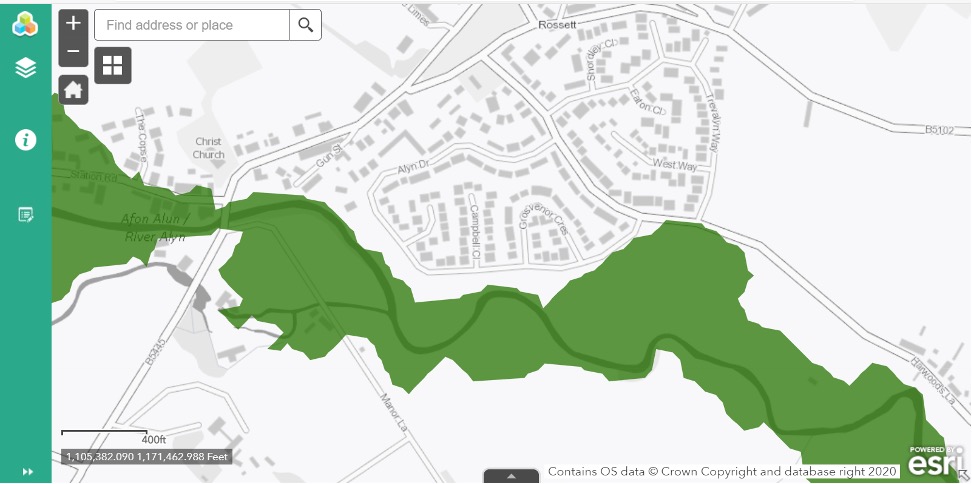
The above image demonstrates that no confidence can be placed on statements that no reservoir flooding is likely when such maps and incident photographs exist. The importance of Figure 4 shows that in addition to ignoring the influence of the River Dee there remains a reservoir flood risk on the adjacent C2 flood plain that should be added into the Hydraulic modelling considerations. Research has shown that the sluice gates at Bala Lake were opened during the November 2000 incident adding further to the excess water levels along the River Alyn especially above Cooks Bridge from Almere towards Trevalyn.
Development Advice Maps for the Area
Much local detail has been provided to Betts Hydro in letter form with accompanying appendices but with the exception of the Historic Map circa 1937 no use of the data has been perceived. In using the Historic Map Betts have failed to understand that the map shows a stream to a distant pond but this stream activity is from a spring and supports the large Alder Tree in the Northern Parcel adjacent to where the spring rises. No reliance can be placed on Betts assumptions on the direction flood waters will traverse the village and enter Trevalyn Way, as this has not been the case when fluvial flooding has occurred in the area.
Raising of Topographic Levels & Flood Flows Through the Site
The proposal to artificially raise the site levels to protect the new development is carefully concealed by Betts Hydro in the wording of the latest FCA.
The raising of the Finished floor Levels of the houses by an average of 640mm is still unsatisfactory and should be refused on two counts (1) the scale (height) of the properties is limited by the agreed LVIA to 7.30m above topographic level to ridge and results in Condition 1 being failed on the aggregate height of ground uplift plus building height exceeding the LVIA height imposition and (2) the concept of building up the site contravenes WCBC Policy EC12 and EC13 as well as Tan15 (2004) paragraph 8.3. In addition, the sewage pumping station will still be placed at risk as the finished floor level will again be lower that that of the adjacent raised land. The effects on the electricity sub-station still need to be evaluated as the indicated location is patently unsuitable on its impact on the houses in Trevalyn Hall View.
The impression is created by the wording of Paragraph 5.1.25 that finished floor levels will only be raised 150mm above ground level. What is not explained is that the existing topographic levels are to be raised by varying amounts and then the dwelling floor slabs will be constructed upon these newly raised levels. Indications are that only minor changes have been made to the FFLs in the last FCA Ver 2.1 dated 18th June 2021.
NRW kept asking the Developer for the finished floor levels of all the properties, but Castle Green never appeared to respond so RFG have taken the time to create a record of all the existing ground levels and dwelling finished floor levels so the paragraph below is a brief summary of that record.
Of the total properties involved 11% have had the FFLs altered, 3 properties have been raised further whilst 11 properties have had slab levels lowered. The resultant average FFL has been reduced by 37mm by the latest FCA proposals the remaining 118 properties FFLs are unchanged from the earlier submission. This clarifies the point being made in Paragraph 5.1.25 that having raised the floor levels by an average of 640mm “No properties are predicted to flood by more than 600mm with the majority remaining flood free.” In addition, the same FCA paragraph states “The peak flood depths in the Southern Development parcel would be approximately 0.55m in rear gardens”.
It is clear that the hydraulic modelling shows that unless the site levels are raised by an average of 640mm all properties will be subject to substantial flood risk. It should be noted that in the upcoming revisions to TAN15 the flooding of such gardens is deprecated.
It is noted that there is provision for overtopping of the infiltration ponds on the northern site. As advised previously the exceedance from this development, as well as placing numerous new houses and the sewage pumping station at risk will ultimately be directed to the existing ditch in Darland High School. The outfall from which will increase the existing flooding to areas of Darland and Lavister. The exportation of such risks cannot be accepted as Planning Policy EC12 and EC13 will be contravened together with a marked conflict with the requirements of TAN15 Section 8.
The information submitted by Betts Hydro continues to base its proposals on building up the general site levels to attempt to use the uplift of levels to permit some form of SUDs (Sustainable Drainage) infiltration. The water table on both the northern & southern parcels has always been very high and the water infiltration trial pits were excavated in October 2020 at the end of a long dry spell giving a false representation of typical water table levels. In order to avoid high ground water levels, the drainage proposal requires a site uplift on average of 640mm. It can be seen that the average FFL is 640mm above whereas a number of properties are being raised by 1.50m or more. Such increases with the over height nature of all properties are totally out of scale in comparison with the LVIA height of 7.3m to ridge and should be rejected under Condition 1.0.
The Drainage Management Strategy proposal although marked FINAL contravenes WCBC Policy EC12 and EC13 and will increase runoff into the surrounding areas.
Betts Hydro have already been advised that their Hydraulic Modelling peak flood water predictions do not reflect the evidence submitted by The Environmental Agency Wales (forerunner to NRW) to the UDP Inquiry on 2002 that showed the flood levels. The proposal on the southern parcel of land to convert virtually the whole of the POS (Public Open Space) adjacent to Harwoods Lane is unacceptable. In addition to turning the POS into a large infiltration pond this area immediately abuts the C2 floodplain in Harwoods Lane.
The FCA and Drainage Management Strategy both glibly talk about exceedance in extreme events discharging to a local water course. In the case of the southern parcel it will not be possible to discharge exceedance into the C2 floodplain so the direction of exceedance flow must inevitably travel towards the northern parcel or vainly attempt to raise the Top Water Level on Harwoods Lane. In the northern parcel itself, the exceedance will be discharged into the ditch on Darland School field which is already flooding further down-stream in Darland and Lavister.
In extreme event conditions all exceedance will flow towards the northern corner of the Northern Parcel increasing the flood risk to Trevalyn Hall View, Darland View and the downstream areas of Darland School Fields, Darland and Lavister which are already under flooding pressures. Such proposals are contrary to TAN 15. If the infiltration pond is created adjacent to the Harwoods Lane boundary and the smaller infiltration ponds created on the northern parcel of land the result cannot be claimed as a satisfactory provision of Public Open Space and the whole proposal application should be refused as failing to comply with UDP policy CLF5 as an infiltration pond cannot be used for the POS purposes set out in this UDP policy. It must be noted that in the event of the normal flooding from the track south of Harwoods Lane the infiltration pond on the south of the development will be the first to succumb to flood waters making the location so close to the C2 plain indefensible, so that surface water will discharge into the northern pond areas before run-off flooding to Trevalyn Hall View, Darland View and areas of Darland and Lavister.
Ground Infiltration Conditions are referred to in the Drainage Management Strategy Ver 2.2 Dated August 2021 as encountered by Waterco when ground testing was carried prior to the initial Planning Application. Waterco determined that substantial areas of both the northern and southern parcels of land were underlain with clay deposits. E3P undertook further site investigation work in May/June 2020 and encountered ground water in the majority of test holes at depths 0.5mbgl to 2.5mbgl (Below ground level) and that soakaway drainage would be a feasible option (except in areas of clay). Betts have confirmed that in their tests conducted in October 2020 after a long dry period that groundwater was detected in the majority of holes at 1.20mbgl to 1.9mbgl. From the uncertainty being expressed in both the FCA and the Drainage Management Strategy that neither Castle Green Homes or Betts Hydro know the extent of clay deposits around the two parcels of land and are now requesting an open-ended approval to a SUDs scheme that has not been designed or can be demonstrated to work.
Any Discharge of Condition 7.0 must not be agreed until a fully designed SUDs infiltration scheme has been produced to satisfy all SUDs conditions imposed by the Welsh Ministers in January 2019. Betts have indicated that Castle Green requested investigation of deeper SUDs soakaways but this potential to discharge waste water to a lower depth has been frustrated by the inherent groundwater levels. This should come as no surprise to Castle Green Homes and Betts Hydro as NRW have been advising since 2017 that the development site is located over an aquifer and SPZ1 protection will be necessary to the underlying aquifer.
In the initial site investigations by Tigergeo and Waterco it was established that there were underlying areas of clay and that the whole site was not suitable for SUDs infiltration. Only 12 test pits were dug covering an area of over 6Ha. Subsequent SUDs infiltration tests pits have been dug by Betts Hydro to ascertain whether deeper soakaways are practical rather than the shallow pits excavated by Waterco in 2015. The following is an extract from the Betts Drainage Management Strategy Page 61 :
“Ground Conditions Encountered. As with previous ground investigation ground conditions generally consisted of sands and gravels to depth. With localised clays and sandy clays. Groundwater was encountered in the majority of holes between depths of 1.20mbgl – 1.90mbgl. Only SA03 was recorded as dry during the time of investigation. stability was often recorded as unstable within the SANDS & GRAVELS and instability increased with depth. As such the tests whilst undertaken in general accordance with BRE 365 are not deemed to be fully compliant”.
It is clear that inadequate tests pits have been dug over the whole site to suggest that SUDs soakaways can be provided to achieve satisfactory infiltration of waste water, and what test pits have been provided do not confirm that infiltration can be achieved across the whole site.
Objections to the large areas of the site that could not support infiltration were submitted in 2018 against this application but was totally ignored and this point has been the subject of evidence to the LDP Hearings and the Reserved Matters and Discharge of Conditions pursuant to P/2018/0560 and P/2021/0110 and P/2021/0111.
Condition 7 must not be discharged until it can be shown that both parcels of land can be drained without recourse to the overland ditch in Darland School which already contributes to the flooding of Darland and Lavister. The flooding in the Darland and Lavister area appears to the over development of Housing in the area with little or no control by WCBC with culverts and drains being blocked by housing built on the outskirts of Darland School playing fields.
We place this here as Wrexham Council hide all objection documents from the public, which means no residents can see what other residents are objecting about and how many objections that are being presented, also there is no means to check that your objection has actually been read and placed on file.
