
1.0 Introduction
This is just one of a series of objection reports prepared by the Rossett Focus Group in response to the Castle Green Homes planning application P/2021/0110 & 0111 to discharge reserved matters to the outline planning application P/2018/0560 approved on appeal by a Welsh Government Inspector and Welsh Minister. The formal objection to the development is submitted in accordance with Tan 15 (2004) – Appendix 1 which provides for such evidence to be considered in connection with the Technical Requirements for assessing flood consequences. Note – The Appendix document will open in a new Tab on your browser to make the viewing of references easier.
We will show that the Flood Assesment Report prepared by Betts Hydro (dated Jan 2021) on behalf of Castle Green Homes contains inaccurate information and is hence flawed.
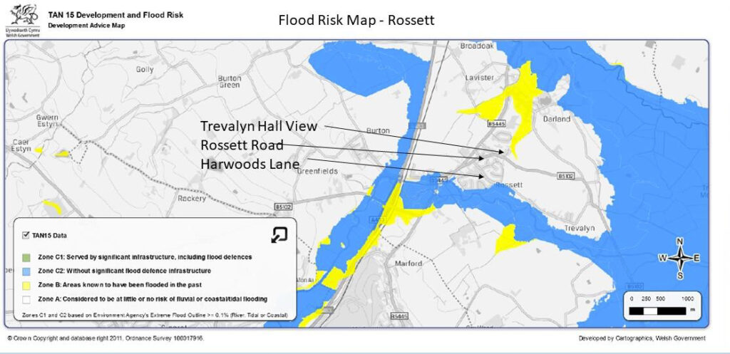
This evidential document sets out the history of the Flooding on both parcels of land including correspondence, statements, photographs and diagrams that show this site has had a history of flooding over a period of at least 40 years. The document has drawn on resource material from both local and national archives and from statements from a number of Residents who witnessed the most recent flooding in 2000 and the Wrexham County Borough Council Duty Flood Officer for the 6th November 2000 event. National Resources Wales show on their Development Advice Maps 2019 Version that the site is located mainly in Zone A (but actually a small part is also in Zone B) and is shown below.
The following paragraphs will demonstrate the site P/2018/0560 (P/2021/0110 & P/2021/0111) has suffered serious flooding in the past and has a history of serious run-off and should be treated in a precautionary manner as advised in PPW11 Paragraph 6.6.22 to oppose any housing development.
2.0 National Resources Wales
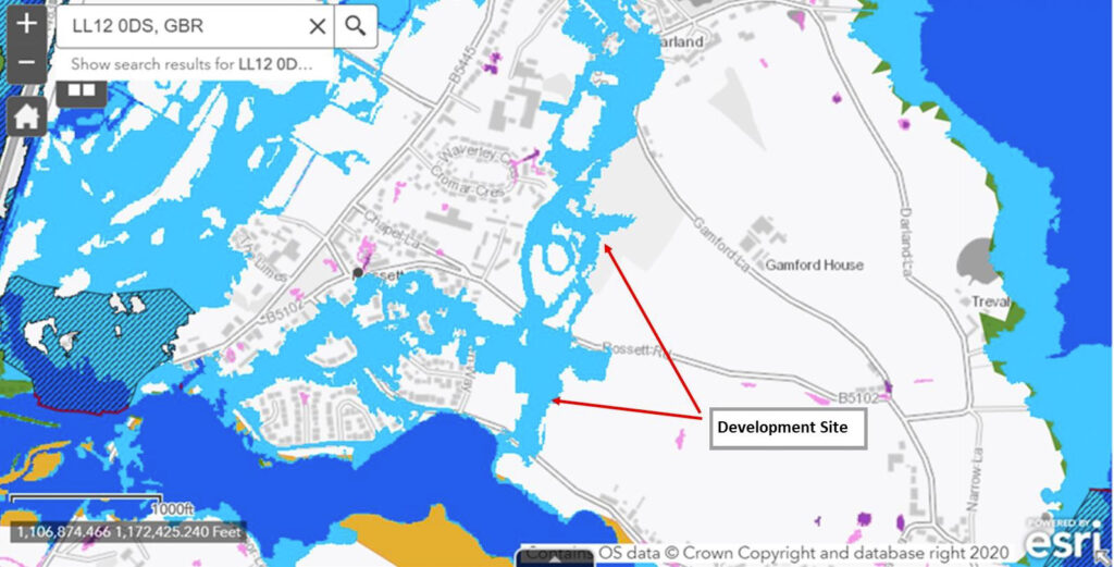
The most definitive maps produced by NRW were updated with effect from the beginning of February 2021 and these are shown in Figure 2 below as Zone 2 and Zone 3 with additional flood areas recorded for the location of the sites now presented for Reserve Matters.
Inquiries were made of NRW in 2020 prior to the release of the updated maps when it was revealed that they have none of their own records of the flood events in 1976 or 2000 and are relying on a Police 2000 helicopter daytime flyby sometime before or after the peak of the flood event that occurred at 11-45pm on the night of the 6th Nov 2000. It can be seen from these latest map layers that the Castle Green Development site is located predominantly in Zone 2 unprotected flood risk areas.
With the proposal to open up the hedgerow to create an access on the section of Harwoods Lane that was reclassified in late 2018 as part of the then C2 flood plain then the southern development parcel of land will in effect be an even further unprotected flood zone somewhere between Zone 2 and Zone 3. It will be seen that there are two small areas on this mapping shown in Green which indicates Reservoir Flooding. In fact, the whole Rossett area which is overlain by the Zone 3 flooding layer was subjected additionally to Reservoir Flooding in 2000 when reservoir sluice gates were opened up higher on both the River Alyn & River Dee. This was denied at the time by The Environment Agency but subsequently admitted as true, so that reservoir flooding with the event of climate change cannot be ruled out as future flood risk. Dark blue indicates Zone 3 and Light Blue Zone 2, Brown: Historic Flood & Green: Reservoir risk.
In November 2018 it was agreed in correspondence that the River Alyn Flood Plain was changed to show that the 6th November 2000 event had officially flooded Harwoods Lane and had levelled with the southern boundary. The correspondence and mapping relating to these changes is shown in Appendix A1.
Unfortunately, NRW have not correlated all the agreed mapping alterations showing agreed flood outlines and the latest NRW peak flood level predictions in the Harwoods Lane area of Rossett are under estimated as will be shown in the documents and commentary that follows. See Sections 6.0 and 7.0 for further details on NRW Peak Flood Level Predictions.
3.0 Local Evidence
Following the acceptance by NRW in November 2018 that the flood plain now abutted the southern boundary of this site the local population in Rossett, Lavister and Trevalyn were asked to provide any additional photographic evidence showing the 6th November 2000 flooding. In addition to the 103 photographs of historic flooding of the River Alyn in Rossett over the last 40 years a local resident in Trevalyn brought forward a video of the extent and depth of flooding on the 6th November 2000 during daylight hours. This video can be viewed by following the YouTube link https://youtu.be/HwR_AT8qpRc .
Two residents of Trevalyn came forward earlier in 2018 and were able to demonstrate independently and to corroborate the extent of the flooding on Harwoods Lane when it became impassable on the afternoon of the 6th November 2000. The flood lines on Harwoods Lane confirmed the statements of the Duty WCBC Flood Officer in his earlier correspondence relating to site P/2018/0560. The Appendix B contains statements from Mr DH, Mr DR and Mr DG (names redacted for privacy). See Appendix B1, B2 and B3. Local residents have complained about nuisance run off flooding from the lower parcel and this has been evident for a number of years. On the 6th November 2000 Flooding from the River Alyn resulted in major runoff into Trevalyn Way and Moss Green. This runoff was recorded early afternoon of the 6th November prior to the issue of sandbags and photographs showing this runoff are shown in Appendix B4.
In January 2021 the River Alyn again broke its banks and flooded Harwoods Lane, the River having reached only 2.337m above normal at the Alyn Bridge gauging station in Rossett. The southern portion of land was not flooded on this occasion by the River Alyn but the field was covered in substantial areas by standing water from Pluvial flooding. No run-off was experienced in Moss Green or Trevalyn Way in January 2021 totally contrary to the 2000 event when severe run-off was experienced and recorded. Regrettably the northern portion of land due to the topographic levels resulted in substantial run-off into Trevalyn Hall View and Darland View creating local flooding problems. The run-off was so significant in Darland View that No x Darland View was flooded and sand bagging was needed to the property to limit the inherent internal damage. See Appendix D5 Photos of Darland View Flooding January 2021. Photographs of internal flooding are available have been redacted.
4.0 Topographical and Flood Line Analysis
The statements of the WCBC Duty Flood Officer were examined in greater detail and the information therein was compared with the topographical details contained in the recent planning application for development of the site. On 7th February 2019 topographic levels on Harwoods Lane were checked and it was established that the flood levels on the Lane had exceeded the gate threshold to the site by some 140 mm thus confirming the statements of both Trevalyn Residents that they witnessed flood water entering the lower portion of Site P/2018/0560.
The residents of Moss Green and Trevalyn Way have stated in correspondence that during the afternoon of 6th November 2000 they were issued with sandbags to divert the flood water runoff from the lower field from entering their homes and garages. Wrexham CBC denied at the UDP hearing in 2002 that they had ever issued sandbags to Residents in Rossett. This has been shown to be totally untrue now that the Duty Flood Officer has confirmed that sandbags were deployed in Rossett locally to Site P/2018/0560 to alleviate flooding to dwellings in both Trevalyn Way and Moss Green. In addition a line of sandbags were deployed on Harwoods Lane much closer to Trevalyn to reduce flooding to the adjacent hamlet.
NRW have none of their own records of the actual flooding event 6th November 2000 as all their resources were primarily directed towards the serious flooding at Bangor-on Dee. Wrexham CBC were left to handle the serious flooding at Rossett & Trevalyn and the Army was called in to assist with flood defences. WCBC highways staff from Gwersyllt Depot supplied sandbags to local residents despite denials by WCBC Planning Staff.
WCBC flood records appear only to commence in 2010 some 10 years after the last major flood event in Rossett and have not provided any useful information about this or prior flooding events.
5.0 Surface Water & Flooding Issues North & South Land Parcels
5.1 Northern Land Parcel
The northern parcel of land has a history of waterlogging and flooding. NRW flood mapping confirms that the site has flooded in the past. Correspondence between the NRW and the recent developer confirms that the field contains a Secondary Aquifer that requires protection from contaminated ground water. The statement of Mr DG (Appendix B3) indicates that the northern parcel contains a spring that prematurely curtailed building on the site in about 1958. Archive research shows that a stream existed on the site in about 1940 and terminated in a pond at the most northern part of the site. The Archive map is shown in Appendix D1
Consultation of the 2019 Tan 15 Flooding Advice Map Figure 1 above shows a record of Historic Flooding on this parcel of land. Enquiries suggest that the historic flooding was mainly connected to the flood levels on the River Dee. Recent information revealed by a developer on another site in Rossett/Lavister has shown that hydraulic modelling on the River Alyn is materially affected by the levels of the River Dee and confirms the testimony given to the 2002 UDP Inquiry by Mr G, an Environmental Agency Officer responsible for this stretch of the River Alyn in 2000.
5.2 Southern Land Parcel
The Southern Parcel of land was similarly assessed by the above FCA Consultant and this again showed that there were substantial areas of the field that were underlain with clay deposits again rendering a simple SUDS drainage scheme unsuitable. With the prospect of future flooding from the River Alyn mirroring that of 2000 and 1976 considerable run off from this field can be expected without any further development. The large areas of clay deposit again confirm the Residents’ contention land does not drain properly and run off is a continuing problem for adjacent dwellings. The underlying clay areas on this southern parcel of land are also illustrated on a recent example housing layout shown at Appendix D4.
6.0 Local Historical Evidence Illustrating Higher Rossett Flood Outlines
The highest NRW acknowledged height 2.193 m above normal of the River Alyn at the Alyn Bridge monitoring station occurred on the 13th June 2019 however the peak recorded level 20th January 2021 indicates that a peak river height was recorded of 2.337m above normal at 20-30hrs.
In 2000 the change in the level of the River Alyn rose 2.79m above normal adjacent to the B5445 Alyn Bridge resulting in the surrounding area being substantially flooded and flood water was seen entering Site P/2018/0560 at its southern most point, see Section 3.0 above. It should be noted that the 1976 event resulted in a rise in river level of 2.89m as recorded in Gun Street Rossett, and this flood outline has been apparently recorded on the 2021 NRW mapping.
If Climate change factors are applied to the 1976 flood level in Gun Street the flooding in the Harwoods Lane area will substantially increase over and above that experienced recently. NRW have not disclosed the height of their flood outline in the vicinity of Harwoods Lane near the development site but with their unwillingness to update and show the height of 2.337m above normal on their monitoring data it must be assumed that the 2.193m figure was used to inform the latest hydraulic modelling which in turn results in a peak flood level in this area of 13.60m AOD which is markedly above the majority of both parcels of land in this proposed development.
This peak level indicates a continuing serious potential flood risk to the site now and in the years to come as with the grain of the land falling naturally all the way to Darland the areas of Trevalyn Hall View and Darland View will be at greatest run-off flood risk. Also, at risk will be the sewage pumping station which will be located at the lowest point of the development. Any serious flooding to this pumping station will risk ground water contamination of the aquifer under the development site which must be protected due to its SPZ1 classification.
7.0 Recent Developments
Since the beginning of June 2019 when considerable surface water flooding occurred on the southern parcel of land and detailed correspondence with NRW on this topic and WCBC Flood Officer has taken place. In July 2020 a complaint and a Freedom of Information request was made to NRW the results of which revealed that NRW have none of their own records of the Rossett flood events in 1964, 1976 and 2000 and are relying on a helicopter flyby to inform the 2000 event sometime before or after the night time peak at 11-45pm on 6th November 2000.
It was as part of this FOI that NRW announced that they now regard the above development as located within an unprotected Zone 2 flood risk area. See Page 30 Appendix E. NRW have been challenged on the accuracy of recorded flood outlines in the Harwoods Lane area unfortunately NRW Evidence shown on page 3 of their response in Appendix 1 (November 2018) conflicts considerably with the 2000 Recorded Flood Lines Map issued with response ATI-19893b on Page 31 of this annex.
Putting it simply the Photographs accepted by NRW for the adjustment of the C2 floodplain on Harwoods Lane (November 2018) show greater flooding than the Recorded Flood Outlines accompanying response ATI-19893b so that the predicted peak flood level of 13.60m AOD is a marked under estimate and with the correct and accepted flood outlines, therefore the peak flood level will be higher indicating further risk to the proposed development. This continuing anomaly between the 2000 NRW recorded flood outlines has already been referred to WG Planning Division who are dealing with the update of Tan 15 and the new 2021 NRW flood mapping.
8.0 Flooding Insurance
Over the last few years there has been an increase in the number of Insurance Companies refusing property insurance to residents living close by to site P/2018/0560. The known insurance companies comprise LV=, NFU, AXA, Direct Line and Allianz. The importance of property Insurance was subject to WG Planning advice in 2014 and issued guidance to LPA Chief Planning Officers. Planning Circular WG0701-14 Planning Policy on Flood Risk and Insurance Industry Changes advised that failure to gain flood insurance cover would affect deliverability of dwellings on a development site. It is now common place for existing properties to be refused flood insurance especially in the Harwoods Lane, Trevalyn Way, and Trevalyn Hall View areas which abut both the South & North Parcels of land being less than 400m from the River Alyn.
9.0 Conclusions
This document confirms the observations of local residents and the year 2000 WCBC Duty Flood Officer that the P/2018/0560 southern parcel of land was severely flooded on 6th November 2000. In addition the northern parcel of land has been subject to historic flooding in the past.
Examination of ground and other conditions show that the northern parcel contains both a spring and an aquifer. All of these issues together with prospective climate change risks require a precautionary approach to be taken towards flooding as recommended by TAN 15 and PPW11. Any new development on site pursuant to P/2018/0560 will not qualify for “Insurance Flood Re” as it is post 2009 and cannot be described as deliverable.
Overall, the precautionary approach to this site development is indicated and it recommended that it should not be approved for housing development just on grounds of flooding alone.